


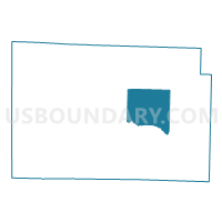
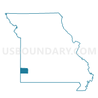
NORTH MADISON Voting District, Jasper County, Missouri
About
Outline

Summary
| Unique Area Identifier | 608768 |
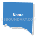
| Name | NORTH MADISON Voting District |
| County | Jasper County |
| State | Missouri |
| Area (square miles) | 36.72 |
| Land Area (square miles) | 36.48 |
| Water Area (square miles) | 0.24 |
| % of Land Area | 99.35 |
| % of Water Area | 0.65 |
| Latitude of the Internal Point | 37.21718320 |
| Longtitude of the Internal Point | -94.22538630 |
Maps

Graphs
Select a template below for downloading or customizing gragh for NORTH MADISON Voting District, Jasper County, Missouri


Neighbors
Neighoring Voting District (by Name) Neighboring Voting District on the Map
- CARTHAGE WARDS 2-1 \ 2-2, Jasper County, MO
- LINCOLN / SHERIDAN Voting District, Jasper County, MO
- MARION Voting District, Jasper County, MO
- MCDONALD Voting District, Jasper County, MO
- SOUTH MADISON Voting District, Jasper County, MO
Top 10 Neighboring County Subdivision (by Population) Neighboring County Subdivision on the Map
- Marion township, Jasper County, MO (15,137)
- Madison township, Jasper County, MO (2,502)
- Preston township, Jasper County, MO (1,446)
- McDonald township, Jasper County, MO (810)
- Sheridan township, Jasper County, MO (412)
- Lincoln township, Jasper County, MO (296)
Top 10 Neighboring Place (by Population) Neighboring Place on the Map
Top 10 Neighboring Elementary School District (by Population) Neighboring Elementary School District on the Map
Top 10 Neighboring Unified School District (by Population) Neighboring Unified School District on the Map
- Carthage R-IX School District, MO (23,293)
- Sarcoxie R-II School District, MO (4,107)
- Jasper County R-V School District, MO (2,971)